“Three Scars Through Lower Manhattan Tell The Story Of The Birth Of Car Culture” by Josh Fruhlinger tells a good story, although the headline (which was not necessarily written by Mr. Fruhlinger) is a bit misleading. The scars from car culture are everywhere in Manhattan, in a difficult to see form: the driving roadbed of many streets has been widened at the expense of the sidewalks. The three scars that the article discusses are the extension of Seventh Avenue and Sixth Avenue south into the pre-grid portion of the city and the radical widening of Houston Street. The reason I say the headline is misleading is that all three of these cuts – Robert Moses once described cutting a controlled-access highway thorough a built-up portion of the city as using a “meat axe” – were made partially for the new streets and partially to build new subway lines. As pleasant as it might be to image Greenwich Village without any wide streets between Fifth Avenue and the Hudson River, it’s horrifying to imagine getting around Manhattan without the Seventh Avenue and Sixth Avenue subways that run under those three cuts.
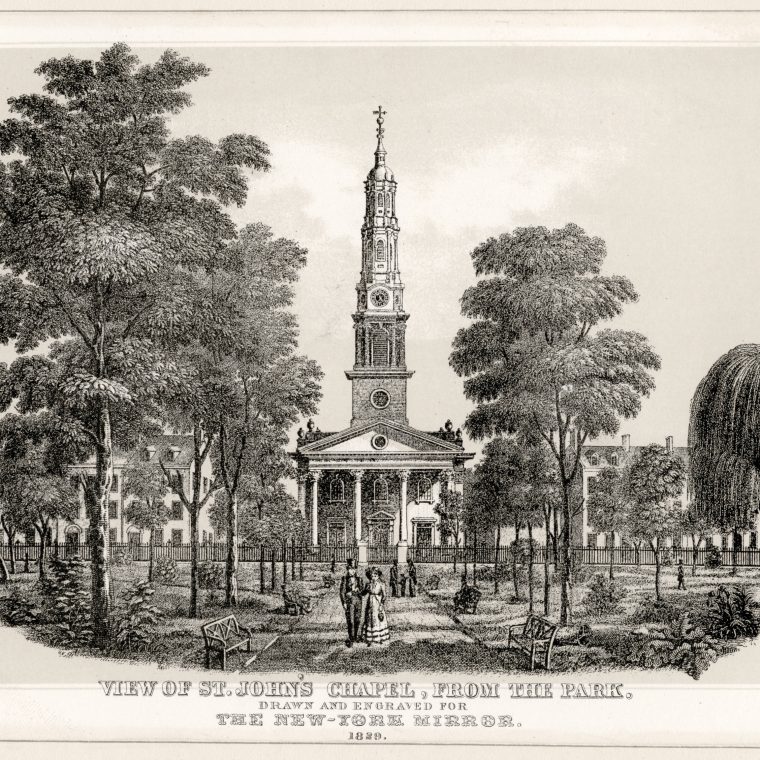
There is a long history of building big new streets through built-up parts of cities. The most famous is probably Haussmann’s work at Paris in the mid-1800s, but the fact that there was a street in Ancient Rome called the Via Nova suggests how old the practice is. Other types of changes are made to existing built-up areas, of course, and I wanted to add to the three scars in the article a fourth nearby and worthy of note: the fate of St. John’s Park. The picture above is a (only slightly fanciful) view from the 1820s, with the houses of the wealthy surrounding a church and a square park. Here it is in 1853:

The park is bounded by Hudson Street on the west, Laight Street on the north, Varick Street (with the church) on the east, and Beach Street on the south. Note, for future reference, Canal Street on the upper right. But it was doomed. The New York Central Railroad was formed in 1853 by combining a series of short railroads; its run from Albany to Buffalo meant that rail could replace the Erie Canal. The Hudson River Railroad, at sea level from New York City to Albany, opened in 1851; its run meant that rail could replace most of the river traffic. By 1853, the neighborhood surrounding the park was already starting to decline as a location for high-end residences, as fashion moved uptown, and in 1866 the combined NYCRR/HRRR bought the park as a location for a freight terminal to serve lower Manhattan. The surrounding neighborhood quickly became industrial and stayed that way for a century, more or less. Here’s 1894, with some of the old houses surviving on Hudson Street, repurposed as boarding houses or commercial use:

That freight terminal was served by a railroad line down Eleventh Avenue, and then by an elevated rail line starting in 1933. The elevated line is now the High Line park. Here’s the terminal in 1930, as the elevated line was being constructed:

Note the railroad spurs from the terminal to the tracks on Hudson Street. What’s not prominent on this map is the Holland Tunnel under the Hudson River which opened three years earlier. You can just make out the tunnel exit parallel to and south of Canal Street. Car traffic was on the rise and industrial freight traffic was falling…by 1956, the tunnel was more important that the terminal, and the terminal had been demolished:

“Block 213” is a big open space, shortly to be filled with a new “exit plaza” for the tunnel. It looks like a neat solution from the air or on a map:
In reality, it’s a huge car-centric void in the middle of an otherwise pedestrian-and-transit-oriented neighborhood. The vaguely park-like pretensions of the leftovers of land between the highway ramps are both annoying and useless in themselves and a reminder that, with the railroad freight terminal gone, we could have had St. John’s Park back.


You must be logged in to post a comment.