The name “Coney Island” is, generically, a long (east-west) and narrow (north-south) peninsula at the southern tip of Brooklyn, defined geographically by the Coney Island Creek on the west and Sheepshead Bay on the east. People have done a much better job defining the peninsula: the Belt Parkway now does a nice job cutting it off from the adjoining areas. The far west end of the peninsula is Sea Gate, the west middle is Coney Island proper, the east middle is Brighton Beach, and the far east end is Manhattan Beach. Except for the presence of the beach and the boardwalk, and in Coney Island the amusement parks, it looks much like the rest of Brooklyn, with a mixture of small commercial buildings, houses, and apartment houses, served by five subway lines.
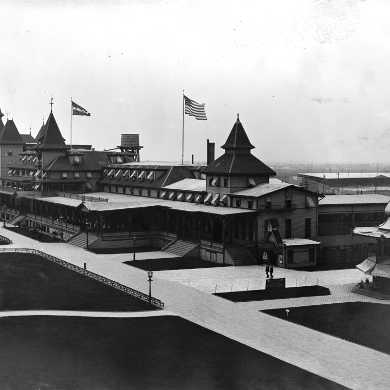
Not that long ago – in, say, 1900 – it was quite different. The built-up area of Brooklyn was still to the north, and there were still resort hotels on the beach. The picture above is the Manhattan Beach Hotel in first decade of the 1900s. The first subways were years away, but there were elevated or railroads on each of the current subway routes, which is why those routes have picturesque secondary names (e.g., the N train is the Sea Beach line) to this day. In short, in the late nineteenth century, people seem to have thought of southern Kings County – the not-yet-urbanized area that is now southern Brooklyn – as a never-to-be-developed wilderness separating the city from the ocean. Multiple railroads were built as a combination of commuter service for a small number of people and summertime access to the amusement parks, racetracks, and beaches. A good example is the New York & Manhattan Beach Railroad, a narrow (3-fooot) gauge road opened in 1877 and absorbed into the Long Island Railroad empire in 1880. A map of the line:

The light dash-dot line running through Greenwood Cemetery and Prospect Park is labelled “City Line” east of the park, so this is before the city of Brooklyn swallowed the southern half of the country. Flatbush, Flatlands, Gravesend, and so on, now neighborhoods in Brooklyn, were still independent towns. The heavy dashed lines indicate elevated trains and the LIRR. The tree-like route of the railroad makes sense if you think of the purpose of the NY&MB as to funnel people as effectively as possible from Brooklyn and Manhattan to the beach: the northern terminals are at New York ferries and Brooklyn elevated trains. The branch to Prospect Park disappeared long ago; the Manhattan Beach branch (the trunk of the tree) was abandoned in the 1930s, and the reminder lives on as an LIRR freight line. Much of the Manhattan Beach branch ran parallel and immediate adjacent to the Brighton Beach Railroad, which was eventually absorbed into the BMT subway and its grade-crossings eliminated. Here’s a modern picture of the remnants of the Neck Road station of the NY&MB on the right and the station of the current Brighton Line of the subway (B and Q trains) on the left:

Pictures of the NY&MB back in the day make it look like a railroad out in the country, and its abandonment has created at least one odd real estate problem: unclaimed land in New York City. The surprisingly convoluted corporate history and the paraphernalia of a full-sized railroad really can’t hide the fact that this was a basically a toy train, running a few miles to carry people to the beach, and made obsolete rather quickly by the growth of the city and the extension of regular mass transit. Given the presence of the Brighton Line, it’s hard to even feel nostalgic for the service: we’d gain more by improving the existing subway line than by having the NY&MB still around.


You must be logged in to post a comment.