Since the Dutch colonists here, in a misguided attempt to make New Amsterdam more like Amsterdam, dug some small canals in lower Manhattan, a lot of people assume that’s where the name “Canal Street” comes from. There’s a pretty simple way to disprove that: during the Dutch period of our history, the town never extended north of the wood palisade at what’s now Wall Street, and Canal Street is about a mile further north. In any case, there was a canal, of sorts, at Canal Street and it had some engineering implications. We have to begin, as with any discussion of the original topography of Manhattan, with the Viele Map:

This shows the best estimate we have of the original topography (with modern streets laid over it), as drawn by Viele in 1865, after 230 years of landfill and other alterations. Tan indicates landfill areas, light green indicates solid land with the hatching indicating hills and valleys, and dark green indicates swamp. Landfill along the rivers hadn’t ended in 1865, and a modern map overlaid on this would show the edges pushed still further outward. (On a side note, the parts of lower Manhattan that flooded during Hurricane Sandy coincide quite well with the landfill shown on this map.)
The cut into the very southern tip of the island (far left, as north is to the right) is the Broad Street canal. The light-green plateau a bit north of that is City hall Park, formerly the Commons. North of that is a small body of water with a sort of three-lobed outline, the Collect Pond. This was a reasonably large fresh-water pond and served as a source of drinking water for some time before adjacent industry spoiled it…around 1800. The pond was fed by springs and ground water, and drained to the swamp north and west of it, in what’s now northern TriBeCa and southern SoHo. If you look at the dark green representing that swamp, there’s a strong diagonal line running through it tilted just to the right of straight up the page. That’s the western half of Canal Street. Shortly after 1800, the city tried to build a drain for the springs to allow for filling in the pond, which sort of worked. But the drain was not adequate and was replaced by an open drain, called a canal, following the line that is now Canal Street. The canal inevitably degenerated into a sewer and was eventually buried.
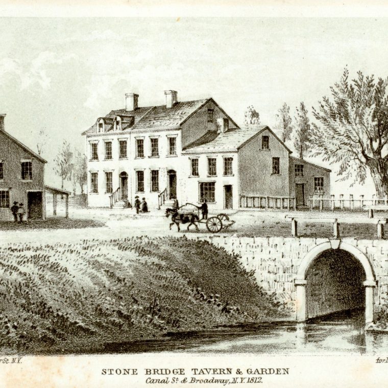
The picture at the top shows a probably inaccurate view of Broadway crossing the canal on small stone bridge. This was drawn in 1881, supposedly showing the conditions in 1812. Here’s an even less accurate view, making an outlying part of the city, only recently removed from being a swamp, look vaguely like a European capital:

That swampy area has very poor soil to this day, and a lot of the cast-iron-front buildings in southern Soho are far from plumb.
In short: you can bury an unwanted water course, but that doesn’t mean it’s gone.


You must be logged in to post a comment.